
50 villages flooded in Cox's Bazar; hundreds of thousands of Rohingya at risk of landslides
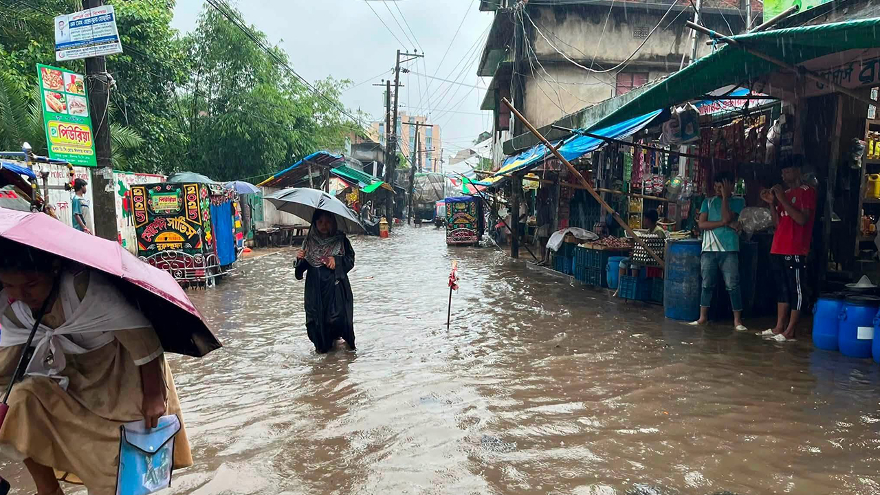
Following the deaths of nine people, including eight Rohingya refugees, caused by continuous heavy rainfall in Cox's Bazar, at least 50 villages across the district have been inundated. According to camp authorities and local administration sources, persistent rainfall has placed around 20,000 local families and at least 100,000 residents of the Rohingya refugee camps in Ukhiya and Teknaf at high risk of landslides.
Meanwhile, a connecting bridge in the island upazila of Kutubdia has collapsed due to strong water currents. Water levels in the Matamuhuri River in Chakaria and the Bakkhali River in Cox's Bazar Sadar have also risen rapidly.
Assistant Meteorologist Md. Abdul Hannan of the Cox's Bazar Meteorological Office said that the district recorded 267 millimetres of rainfall during the 24 hours from 12:00 pm on Sunday. He added that heavy rainfall is likely to continue over the next several days.
Local representatives and residents said that low-lying areas including Samitipara, Kutubdiapara, Eidgaon Upazila headquarters, areas surrounding the district hospital and land office, as well as Sabrang, Shah Porir Dwip, Teknaf Sadar, Hnila, Hwaikyong, and Baharchhara in Teknaf have been submerged. Several sections of the Cox's Bazar–Teknaf highway, five villages in Kutubdia, and most parts of Dhalghata Union in Maheshkhali have also been flooded.
In addition, floodwaters have entered at least 40 shelters in Rohingya Camp No. 2 in Ukhiya. Waterlogging on roads has disrupted traffic, causing severe hardship for students and local residents.
Teknaf Upazila Nirbahi Officer (UNO) S.M. Anik Chowdhury said that residents of hilly and low-lying areas have been advised to remain on maximum alert. If conditions deteriorate further, people living in high-risk areas are being urged to evacuate immediately to designated shelters and maintain close contact with the administration in case of emergencies.
20,000 Families at Risk
According to the Cox's Bazar Forest Department, around 20,000 families outside the Rohingya camps are living on vulnerable hill slopes and foothills across the district. Officials said that approximately 13,000 families are located within the jurisdiction of the South Forest Division, while another 7,000 fall under the North Forest Division.
High-risk settlements include Lighthouse, Shaikatpara, areas adjacent to the Circuit House, Mohajerpara, South Ghonarpara, Badshaghona, Baidyaghona, Middle Ghonarpara, Pahartali, Kolatoli Adarsha Gram, Jhirijhirikua, and Link Road in Cox's Bazar town. Similar vulnerable settlements have expanded significantly over the past three years in PMkhali, Khurushkul, Maheshkhali, Ramu, Ukhiya, and Teknaf.
Rising Concern in the Rohingya Camps
Following the clearance of nearly 8,000 acres of forest land in Ukhiya and Teknaf to establish 33 Rohingya refugee camps in 2017, approximately 1.2 million registered Rohingya refugees are now living in the camps. Of them, at least 100,000 people are currently residing in areas considered highly vulnerable to landslides.
Commanding Officer of the 8th Armed Police Battalion (APBn) in Ukhiya, Md. Riaz Uddin Ahmed, said that despite the heavy rain, authorities are conducting loudspeaker announcements and other awareness activities to relocate refugees living in high-risk areas to safer locations.
Ukhiya Fire Service Station Officer Dollar Tripura said that before the monsoon season began, several coordination meetings had been held with Disaster Management Committees (DMCs), camp leaders (Majhis), and community representatives. Regular public announcements are being made urging people to leave landslide-prone areas during periods of intense rainfall and move to designated shelters.
Refugee Relief and Repatriation Commissioner Md. Mizanur Rahman said that continuous rainfall has significantly increased the risk of landslides in the camps, and those living on unstable hill slopes are being advised to relocate immediately. Warning messages are also being disseminated throughout the camps.
Precautionary Measures in Chakaria
The Chakaria Upazila administration has been making public announcements throughout the day, urging residents living at the foot of hills to move to safer locations. According to official estimates, around 15,000 people living in the hilly areas of Khutakhali, Dulahazara, Fasiakhali, Kaiyarbil, and eight other unions are currently at risk.
Syed Alam, a resident of Islamnagar village in Kaiyarbil Union, said that landslide fears return every monsoon season. Although the administration has advised people to evacuate, many residents are still unwilling to leave their homes.
Chakaria Upazila Nirbahi Officer Shahin Delwar said that authorities are receiving continuous updates from all unions and taking necessary measures to evacuate people from high-risk areas.
Bridge Collapses in Kutubdia
Continuous heavy rainfall has caused a connecting bridge between Shahajirpara in Lemshikhali Union and the Malamchar area of Kaiyarbil Union in Kutubdia Upazila to collapse.
Local resident M. Shahidul Islam said that around 9:00 am on Monday, excessive waterlogging and strong currents washed away the soil beneath the bridge, causing it to collapse and severing road communication between the affected areas.